ViewTube

ViewTube
Sign inSign upSubscriptions
Filters

Upload date

Type

Duration

Sort by

Features

Reset

7,153 results

CGTN
China launches new remote sensing satellite

China launched a new remote sensing satellite from the Wenchang Spacecraft Launch Site in the southern island province of ...

0:22
China launches new remote sensing satellite

5,282 views

7 hours ago

International Channel Shanghai
#china Launches New Remote Sensing Satellite #InnovateChina #fyp #chinatiktok #technology
0:14
#china Launches New Remote Sensing Satellite #InnovateChina #fyp #chinatiktok #technology

0 views

3 hours ago

Study Hacks-Institute of GIS & Remote Sensing
Precision Agriculture Explained: Estimating Water Use Coefficient with Remote Sensing

Check all details for the upcoming online training program from our website: ...

2:01:34
Precision Agriculture Explained: Estimating Water Use Coefficient with Remote Sensing

211 views

4 days ago

New China TV
Xinhua News | China launches new remote sensing satellite

China launched a new remote sensing satellite from the Wenchang Spacecraft Launch Site in the southern island province of ...

0:34
Xinhua News | China launches new remote sensing satellite

1,011 views

4 hours ago

Spatial Signals
The Third Dimension In Remote Sensing with the NASA AREN Team

Geoff Bland, Andy Henry, Lisa Ogiemwonyi, and Sallie Smith from the NASA AREN (Aerokats and Rover Education Network) ...

43:29
The Third Dimension In Remote Sensing with the NASA AREN Team

0 views

7 days ago

AmeriFlux
2025 AmeriFlux Annual Meeting Day 2 - Remote Sensing Session

... use various remote sensing tools to track canopy phology in evergreens These tools include uh time lapse uh digital cameras or ...

24:48
2025 AmeriFlux Annual Meeting Day 2 - Remote Sensing Session

23 views

6 days ago

Archaeology Quest
How Do Archaeologists Use Multispectral Imagery For Remote Sensing? - Archaeology Quest

How Do Archaeologists Use Multispectral Imagery For Remote Sensing? Have you ever wondered how archaeologists uncover ...

2:48
How Do Archaeologists Use Multispectral Imagery For Remote Sensing? - Archaeology Quest

0 views

6 days ago

GIS Edge
"Master GIS in 30 Days | Learn Mapping, Spatial Analysis & Remote Sensing | Job-Ready Skills!"

Description (SEO Optimized + Persuasive): Unlock the power of Geographic Information Systems (GIS) and build a career in one ...

0:40
"Master GIS in 30 Days | Learn Mapping, Spatial Analysis & Remote Sensing | Job-Ready Skills!"

0 views

7 days ago

MAPIN RI
The 46th Asian Conference on Remote Sensing (ACRS 2025) - Closing Ceremony

Kota Makassar, Sulawesi Selatan, akan menjadi tuan rumah The 46th Asian Conference on Remote Sensing (ACRS 2025), yang ...

1:26:13
The 46th Asian Conference on Remote Sensing (ACRS 2025) - Closing Ceremony

109 views

Streamed 3 days ago

MAPIN RI
The 46th Asian Conference on Remote Sensing (ACRS 2025)

Kota Makassar, Sulawesi Selatan, akan menjadi tuan rumah The 46th Asian Conference on Remote Sensing (ACRS 2025), yang ...

4:37:21
The 46th Asian Conference on Remote Sensing (ACRS 2025)

410 views

Streamed 7 days ago

The World of Agriculture
What Are The Myths About Remote Sensing Accuracy In Farming? - The World of Agriculture

What Are The Myths About Remote Sensing Accuracy In Farming? Have you ever wondered how modern farming techniques are ...

2:35
What Are The Myths About Remote Sensing Accuracy In Farming? - The World of Agriculture

5 views

4 days ago

IIRS ISRO Digital Learning Programme
Workshop on "Advances in Laser Remote Sensing of Forest Ecosystem"

... of this one-day workshop which we are organizing from IRS Dhadun on advances in leisure remote sensing of forest ecosystem ...

6:05:25
Workshop on "Advances in Laser Remote Sensing of Forest Ecosystem"

1,869 views

Streamed 3 days ago

The World of Agriculture
How Does Remote Sensing Measure Soil Health Variability? - The World of Agriculture

How Does Remote Sensing Measure Soil Health Variability? Are you curious about how modern technology helps us understand ...

3:37
How Does Remote Sensing Measure Soil Health Variability? - The World of Agriculture

0 views

5 days ago

Anthropology Insights
Why Is Remote Sensing Essential For Archaeological Excavation Planning? - Anthropology Insights

Why Is Remote Sensing Essential For Archaeological Excavation Planning? Have you ever wondered how archaeologists ...

3:38
Why Is Remote Sensing Essential For Archaeological Excavation Planning? - Anthropology Insights

0 views

5 days ago

The World of Agriculture
Can Remote Sensing Improve Your Farm's Yield Predictions? - The World of Agriculture

Can Remote Sensing Improve Your Farm's Yield Predictions? Are you interested in how modern technology can transform ...

3:14
Can Remote Sensing Improve Your Farm's Yield Predictions? - The World of Agriculture

1 view

7 days ago

nigmt foundation
Spectral Signature: The Key to Remote Sensing Analysis remote sensing #gis #remotesensing

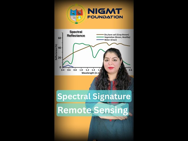
Every object on Earth — whether it's water, soil, vegetation, or urban area — reflects and absorbs light differently. This unique ...

3:28
Spectral Signature: The Key to Remote Sensing Analysis remote sensing #gis #remotesensing

50 views

7 days ago

The Lebanese Center for Water and Environment LCWE
Fundamentals of Electromagnetic Band and Remote Sensing - Session 1

The Lebanese Center for Water and Environment (LCWE) hosted a hybrid training session on Remote Sensing in Agriculture ...

54:15
Fundamentals of Electromagnetic Band and Remote Sensing - Session 1

0 views

7 days ago

Anthropology Insights
How Do Remote Sensing Technologies Guide Archaeological Excavation? - Anthropology Insights

How Do Remote Sensing Technologies Guide Archaeological Excavation? Have you ever wondered how archaeologists ...

3:20
How Do Remote Sensing Technologies Guide Archaeological Excavation? - Anthropology Insights

0 views

5 days ago

The World of Agriculture
Can Spectral Analysis From Remote Sensing Truly Identify Farm Nutrient Deficiencies?

Can Spectral Analysis From Remote Sensing Truly Identify Farm Nutrient Deficiencies? Have you ever wondered how modern ...

3:41
Can Spectral Analysis From Remote Sensing Truly Identify Farm Nutrient Deficiencies?

8 views

6 days ago

The World of Agriculture
How Does Remote Sensing Make Fertilizer Application Precise? - The World of Agriculture

How Does Remote Sensing Make Fertilizer Application Precise? Have you ever wondered how modern farmers achieve precise ...

3:19
How Does Remote Sensing Make Fertilizer Application Precise? - The World of Agriculture

0 views

4 days ago